FILTER: specify central wavelength of each requested filter
MAXIMUM UNSATURATED SURFACE BRIGHTNESS: the total flux of extenced
sources (including the background contribution) to be observed
without saturating the detector and read-out electronics
MINIMUM SURFACE BRIGHTNESS: the expected lowest surface brightness
level of the source (without background contribution) to be detected
MAXIMUM BACKGROUND FLUX: expected background flux at source
position including all components (see Sect. 6.2)
INTEGRATION TIME or S/N: the user specifies the integration
time requested or, alternatively, the required signal-to-noise ratio.
Note that the integration time is the measurement time at each individual position, i. e. at each spacecraft position and at each chopper position.
The following parameters define the orientation and the size of the scan or map:
ORIENTATION OF MAP/SCAN: orientation of scan or map on the
sky. The orientation angle is counted from North over West, South to
East!
TOLERANCE ANGLE: tolerance angle for scan/map orientation to
be provided as large as possible (between 0 and 90 degrees)
NUMBER OF RASTER LEGS: number of raster lines (oriented in spacecraft
Y direction); maximum number is 32
OVERSAMPLING FACTOR: the ratio between the side length of the
C100 or C200 pixels and the separation of the raster legs
NUMBER OF RASTER POINTS IN Y: number of sampling points on
each raster leg; maximum number is 32
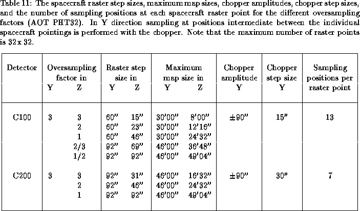
In Y direction the oversampling factor is fixed to 3. In Z direction the following OVERSAMPLING FACTORs can be selected (see also Tab. 11):
for C100: 1/2, 2/3, 1, 2, 3
for C200: 1, 2, 3
 (in each direction) independent
of the detector subsystem (i. e. C100 or C200) and the oversampling factor.
The chopper step size (i. e. the separation of each individual sampling
position on the
sky), however, depends on the detector subsystem. It is 15 for the C100
and 30 for the C200. The oversampling factor in Y direction is
always 3, and the number of sampling
positions in each direction relative to the zero position of the chopper
on each spacecraft raster point is 6
for C100 and 3 for C200. Adding the zero position itself the
total number of sky positions measured on
each spacecraft raster point is 13 for the C100 and 7 for C200,
respectively.
(in each direction) independent
of the detector subsystem (i. e. C100 or C200) and the oversampling factor.
The chopper step size (i. e. the separation of each individual sampling
position on the
sky), however, depends on the detector subsystem. It is 15 for the C100
and 30 for the C200. The oversampling factor in Y direction is
always 3, and the number of sampling
positions in each direction relative to the zero position of the chopper
on each spacecraft raster point is 6
for C100 and 3 for C200. Adding the zero position itself the
total number of sky positions measured on
each spacecraft raster point is 13 for the C100 and 7 for C200,
respectively.
If the NUMBER OF RASTER LEGS is equal to 1 a linear scan is performed. In this case a parameter REPETITION FACTOR can be chosen, which allows for repetition of the scan in reverse direction.
The maximum side length of maps depend on the detector used and the oversampling factor. Note that the orientation of the map is always relative to the spacecraft coordinate system, and the side lengths of the maps are different for the Y and Z axes. Valid parameter combinations and the raster step sizes are given in Tab. 11. Due to spacecraft limitations the maximum number of raster points is limited to 32 in each direction.